| [1] |
Ali, A.M., Darvishzadeh, R., Skidmore, A.K., 2017. Retrieval of specific leaf area from Landsat-8 surface reflectance data using statistical and physical models. IEEE J. Sel. Top. Appl. Earth Obs. Rem. Sens. 10, 3529-3536. .
|
| [2] |
Arekhi, M., Yilmaz, O.Y., Yilmaz, H., Akyuz, Y.F., 2017. Can tree species diversity be assessed with Landsat data in a temperate forest? Environ. Monit. Assess. 189, 586. .
|
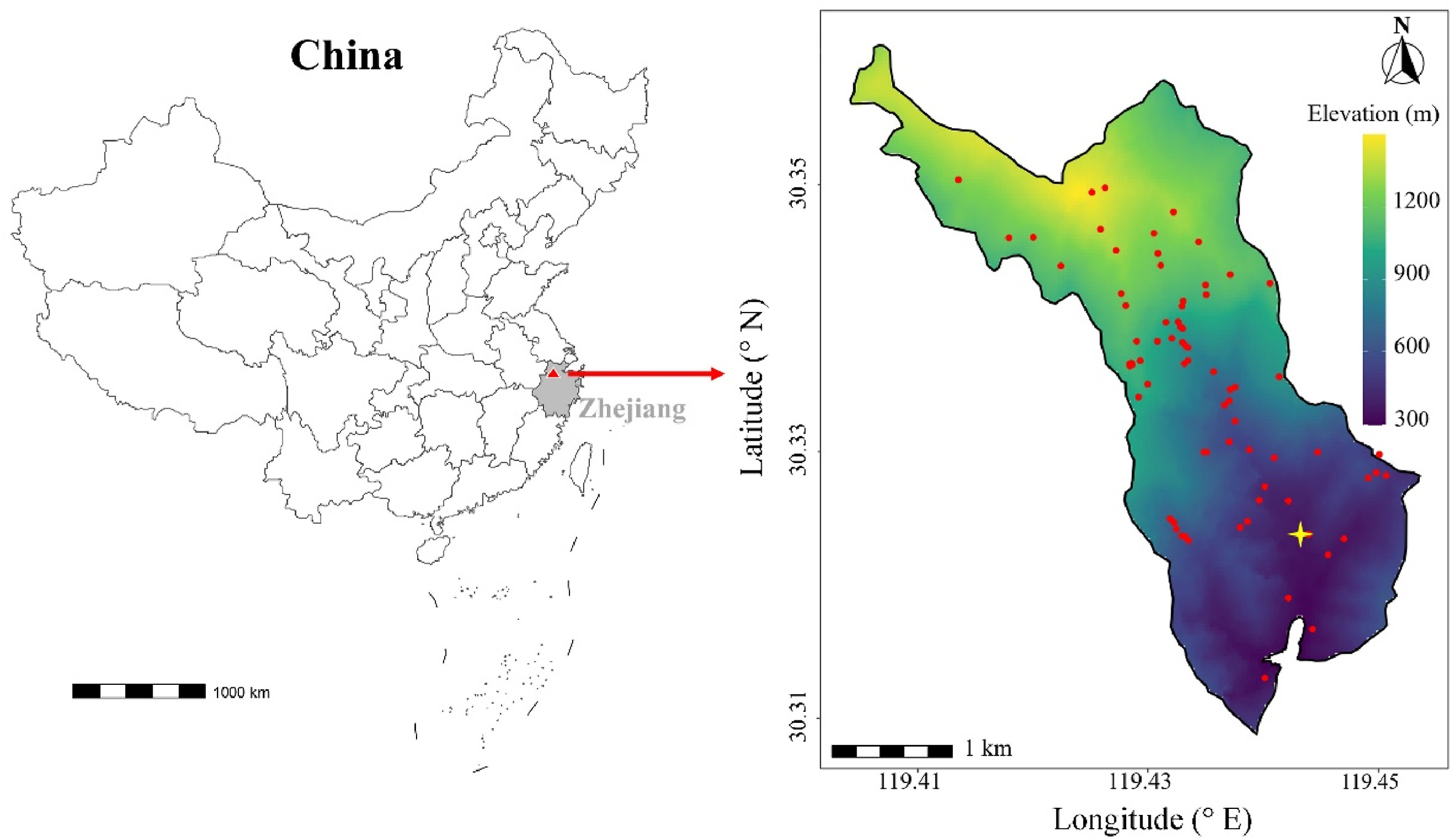
| [3] |
Asner, G.P., Martin, R.E., Anderson, C.B., Knapp, D.E., 2015. Quantifying forest canopy traits: imaging spectroscopy versus field survey. Remote Sens. Environ. 158, 15-27. .
|
| [4] |
Berger, W.H., Parker, F.L., 1970. Diversity of planktonic foraminifera in deep-sea sediments. Science 168, 1345-1347. .
|
| [5] |
Cavender-Bares, J., Gamon, J.A., Townsend, P.A., 2020. Remote Sensing of Plant
Biodiversity. Springer Nature Switzerland, Cham. .
|
| [6] |
Cheng, B., Tong, W., Pan, N., Su, Q., 1991. Chorography of Mountain West Tianmu.
Zhejiang People's Publishing House, Hangzhou (In Chinese).
|
| [7] |
Chrysafis, I., Korakis, G., Kyriazopoulos, A.P., Mallinis, G., 2020. Predicting tree species diversity using geodiversity and Sentinel-2 multi-seasonal spectral information. Sustainability 12, 9250. .
|
| [8] |
Clevers, J.G.P.W., Gitelson, A.A., 2013. Remote estimation of crop and grass chlorophyll and nitrogen content using red-edge bands on Sentinel-2 and -3. Int. J. Appl. Earth Obs. Geoinf. 23, 344-351. .
|
| [9] |
Da, L. -J., Kang, M. -M., Song, K., Shang, K. -K., Yang, Y. -C., Xia, A. -M., Qi, Y. -F., 2009. Altitudinal zonation of human-disturbed vegetation on Mt. Tianmu, eastern China. Ecol. Res. 24, 1287-1299. .
|
| [10] |
Ding, B., 2010. The Flora of Mt. Tianmu. Zhejiang University Press, Hangzhou (in
Chinese).
|
| [11] |
Dogan, H.M., Dogan, M., 2006. A new approach to diversity indices – modeling and mapping plant biodiversity of nallihan (A3-Ankara/Turkey) forest ecosystem in frame of geographic information systems. Biodivers. Conserv. 15, 855-878. .
|
| [12] |
Drusch, M., Del Bello, U., Carlier, S., Colin, O., Fernandez, V., Gascon, F., Hoersch, B., Isola, C., Laberinti, P., Martimort, P., 2012. Sentinel-2: ESA's optical high-resolution mission for GMES operational services. Remote Sens. Environ. 120, 25-36. .
|
| [13] |
Enache, S., 2022. Data Quality Report - Sentinel-2 L1C MSI (No. OMPC. CS. DQR. 01.01-2022). ESA. . (Accessed 2
September 2022).
|
| [14] |
Geladi, P., Kowalski, B.R., 1986. Partial least-squares regression: a tutorial. Anal. Chim. Acta 185, 1-17. .
|
| [15] |
Giam, X., 2017. Global biodiversity loss from tropical deforestation. Proc. Natl. Acad. Sci. USA 114, 5775-5777. .
|
| [16] |
Gorelick, N., Hancher, M., Dixon, M., Ilyushchenko, S., Thau, D., Moore, R., 2017. Google earth engine: planetary-scale geospatial analysis for everyone. Remote Sens. Environ. 202, 18-27. .
|
| [17] |
Guanter, L., Kaufmann, H., Segl, K., Foerster, S., Rogass, C., Chabrillat, S., Kuester, T., Hollstein, A., Rossner, G., Chlebek, C., 2015. The EnMAP spaceborne imaging spectroscopy mission for earth observation. Rem. Sens. 7, 8830-8857. .
|
| [18] |
Hill, M.O., 1973. Diversity and Evenness: a unifying notation and its consequences. Ecology 54, 427-432. .
|
| [19] |
Jiang, X., Zhang, X., 1992. Comprehensive Investigation Report on Natural Resource of
Tianmu Mountain Nature Reserve. Zhejiang Science and Technology Press, Hangzhou
(In Chinese).
|
| [20] |
Kerr, J.T., Ostrovsky, M., 2003. From space to species: ecological applications for remote sensing. Trends Ecol. Evol. 18, 299-305. .
|
| [21] |
Key, T., Warner, T.A., McGraw, J.B., Fajvan, M.A., 2001. A comparison of multispectral and multitemporal information in high spatial resolution imagery for classification of individual tree species in a temperate hardwood forest. Remote Sens. Environ. 75, 100-112. .
|
| [22] |
Kokaly, R.F., Asner, G.P., Ollinger, S.V., Martin, M.E., Wessman, C.A., 2009. Characterizing canopy biochemistry from imaging spectroscopy and its application to ecosystem studies. Remote Sens. Environ. 113, S78-S91. .
|
| [23] |
Kuhn, M., 2008. Building predictive models in R using the caret package. J. Stat. Software 28, 1-26. .
|
| [24] |
Lee, C.M., Cable, M.L., Hook, S.J., Green, R.O., Ustin, S.L., Mandl, D.J., Middleton, E.M., 2015. An introduction to the NASA Hyperspectral InfraRed Imager (HyspIRI) mission and preparatory activities. Remote Sens. Environ. 167, 6-19. .
|
| [25] |
Levin, N., Shmida, A., Levanoni, O., Tamari, H., Kark, S., 2007. Predicting mountain plant richness and rarity from space using satellite-derived vegetation indices. Divers. Distrib. 13, 692-703. .
|
| [26] |
Liu, X., Frey, J., Munteanu, C., Still, N., Koch, B., 2023. Mapping tree species diversity in temperate montane forests using Sentinel-1 and Sentinel-2 imagery and topography data. Remote Sens. Environ. 292, 113576. .
|
| [27] |
Lymburner, L., Beggs, P.J., Jacobson, C.R., 2000. Estimation of canopy-average surface-specific leaf area using Landsat TM data. Photogramm. Eng. Rem. Sens. 66, 183-192.
|
| [28] |
Ma, X., Mahecha, M.D., Migliavacca, M., van der Plas, F., Benavides, R., Ratcliffe, S., Kattge, J., Richter, R., Musavi, T., Baeten, L., Barnoaiea, I., Bohn, F.J., Bouriaud, O., Bussotti, F., Coppi, A., Domisch, T., Huth, A., Jaroszewicz, B., Joswig, J., Pabon-Moreno, D.E., Papale, D., Selvi, F., Laurin, G.V., Valladares, F., Reichstein, M., Wirth, C., 2019. Inferring plant functional diversity from space: the potential of Sentinel-2. Remote Sens. Environ. 233, 111368. .
|
| [29] |
Madonsela, S., Cho, M.A., Mathieu, R., Mutanga, O., Ramoelo, A., Kaszta, Ż., Kerchove, R.V.D., Wolff, E., 2017a. Multi-phenology WorldView-2 imagery improves remote sensing of savannah tree species. Int. J. Appl. Earth Obs. Geoinf. 58, 65-73. .
|
| [30] |
Madonsela, S., Cho, M.A., Ramoelo, A., Mutanga, O., 2017b. Remote sensing of species diversity using Landsat 8 spectral variables. ISPRS J. Photogrammetry Remote Sens. 133, 116-127. .
|
| [31] |
Mallinis, G., Chrysafis, I., Korakis, G., Pana, E., Kyriazopoulos, A.P., 2020. A random forest modelling procedure for a multi-sensor assessment of tree species diversity. Rem. Sens. 12, 1210. .
|
| [32] |
Mohammadi, J., Shataee, S., 2010. Possibility investigation of tree diversity mapping using Landsat ETM+ data in the Hyrcanian forests of Iran. Remote Sens. Environ. 114, 1504-1512. .
|
| [33] |
Newbold, T., Hudson, L.N., Hill, S.L., Contu, S., Lysenko, I., Senior, R.A., Borger, L., Bennett, D.J., Choimes, A., Collen, B., Day, J., De Palma, A., Diaz, S., Echeverria-Londono, S., Edgar, M.J., Feldman, A., Garon, M., Harrison, M.L., Alhusseini, T., Ingram, D.J., Itescu, Y., Kattge, J., Kemp, V., Kirkpatrick, L., Kleyer, M., Correia, D.L., Martin, C.D., Meiri, S., Novosolov, M., Pan, Y., Phillips, H.R., Purves, D.W., Robinson, A., Simpson, J., Tuck, S.L., Weiher, E., White, H.J., Ewers, R.M., Mace, G.M., Scharlemann, J.P., Purvis, A., 2015. Global effects of land use on local terrestrial biodiversity. Nature 520, 45-50. .
|
| [34] |
Ollinger, S.V., Richardson, A.D., Martin, M.E., Hollinger, D.Y., Frolking, S.E., Reich, P.B., Plourde, L.C., Katul, G.G., Munger, J.W., Oren, R., Smith, M.L., Paw, U.K., Bolstad, P.V., Cook, B.D., Day, M.C., Martin, T.A., Monson, R.K., Schmid, H.P., 2008. Canopy nitrogen, carbon assimilation, and albedo in temperate and boreal forests: functional relations and potential climate feedbacks. Proc. Natl. Acad. Sci. USA 105, 19336-19341. .
|
| [35] |
Palmer, M.W., Earls, P.G., Hoagland, B.W., White, P.S., Wohlgemuth, T., 2002. Quantitative tools for perfecting species lists. Environmetrics 13, 121-137. .
|
| [36] |
Pau, S., Nippert, J.B., Slapikas, R., Griffith, D., Bachle, S., Helliker, B.R., O'Connor, R.C., Riley, W.J., Still, C.J., Zaricor, M., 2022. Poor relationships between NEON airborne observation platform data and field-based vegetation traits at a mesic grassland. Ecology 103, e03590. .
|
| [37] |
Potapov, P., Li, X., Hernandez-Serna, A., Tyukavina, A., Hansen, M.C., Kommareddy, A., Pickens, A., Turubanova, S., Tang, H., Silva, C.E., Armston, J., Dubayah, R., Blair, J.B., Hofton, M., 2021. Mapping global forest canopy height through integration of GEDI and Landsat data. Remote Sens. Environ. 253. .
|
| [38] |
R Core Team, 2020. R: A Language and Environment for Statistical Computing. R
Foundation for Statistical Computing, Vienna, Austria. .
(Accessed 1 December 2020).
|
| [39] |
Rahbek, C., 2004. The role of spatial scale and the perception of large-scale species-richness patterns. Ecol. Lett. 8, 224-239. .
|
| [40] |
Reichstein, M., Camps-Valls, G., Stevens, B., Jung, M., Denzler, J., Carvalhais, N., Prabhat, 2019. Deep learning and process understanding for data-driven earth system science. Nature 566, 195-204. .
|
| [41] |
Rocchini, D., Marcantonio, M., Da Re, D., Bacaro, G., Feoli, E., Foody, G.M., Furrer, R., Harrigan, R.J., Kleijn, D., Iannacito, M., Lenoir, J., Lin, M., Malavasi, M., Marchetto, E., Meyer, R.S., Moudry, V., Schneider, F.D., Šímová, P., Thornhill, A.H., Thouverai, E., Vicario, S., Wayne, R.K., Ricotta, C., Gillespie, T., 2021. From zero to infinity: minimum to maximum diversity of the planet by spatio-parametric Rao's quadratic entropy. Global Ecol. Biogeogr. 30, 1153-1162. .
|
| [42] |
Schmidtlein, S., Fassnacht, F.E., 2017. The spectral variability hypothesis does not hold across landscapes. Remote Sens. Environ. 192, 114-125. .
|
| [43] |
Schneider, F.D., Morsdorf, F., Schmid, B., Petchey, O.L., Hueni, A., Schimel, D.S., Schaepman, M.E., 2017. Mapping functional diversity from remotely sensed morphological and physiological forest traits. Nat. Commun. 8, 1441. .
|
| [44] |
Schweiger, A.K., Laliberte, E., 2022. Plant beta-diversity across biomes captured by imaging spectroscopy. Nat. Commun. 13, 2767. .
|
| [45] |
Shannon, C.E., 1948. A mathematical theory of communication. Bell Syst. Tech. J. 27, 379-423. .
|
| [46] |
Simpson, E.H., 1949. Measurement of diversity. Nature 163, 688-688. .
|
| [47] |
Torresani, M., Rocchini, D., Sonnenschein, R., Zebisch, M., Marcantonio, M., Ricotta, C., Tonon, G., 2019. Estimating tree species diversity from space in an alpine conifer forest: the Rao's Q diversity index meets the spectral variation hypothesis. Ecol. Inf. 52, 26-34. .
|
| [48] |
Townsend, P.A., Foster, J.R., Chastain, R.A., Currie, W.S., 2003. Application of imaging spectroscopy to mapping canopy nitrogen in the forests of the central appalachian mountains using hyperion and aviris. IEEE Trans. Geosci. Rem. Sens. 41, 1347-1354. .
|
| [49] |
Turner, W., 2014. Sensing biodiversity. Science 346, 301-302. .
|
| [50] |
Ustin, S.L., Gamon, J.A., 2010. Remote sensing of plant functional types. New Phytol. 186, 795-816. .
|
| [51] |
Wang, R., Gamon, J.A., 2019. Remote sensing of terrestrial plant biodiversity. Remote Sens. Environ. 231, 111218. .
|
| [52] |
Wang, R., Gamon, J.A., Cavender-Bares, J., 2022. Seasonal patterns of spectral diversity at leaf and canopy scales in the Cedar Creek prairie biodiversity experiment. Remote Sens. Environ. 280, 113169. .
|
| [53] |
Wang, R., Gamon, J.A., Schweiger, A.K., Cavender-Bares, J., Townsend, P.A., Zygielbaum, A.I., Kothari, S., 2018a. Influence of species richness, evenness, and composition on optical diversity: a simulation study. Remote Sens. Environ. 211, 218-228. .
|
| [54] |
Wang, R., Gamon, J.A., Cavender-Bares, J., Townsend, P.A., Zygielbaum, A.I., 2018b. The spatial sensitivity of the spectral diversity–biodiversity relationship: an experimental test in a prairie grassland. Ecol. Appl. 28, 541-556. .
|
| [55] |
Williams, L.J., Cavender-Bares, J., Townsend, P.A., Couture, J.J., Wang, Z., Stefanski, A., Messier, C., Reich, P.B., 2021. Remote spectral detection of biodiversity effects on forest biomass. Nat. Ecol. Evol. 5, 46-54. .
|
| [56] |
Woodcock, C.E., Strahler, A.H., 1987. The factor of scale in remote sensing. Remote Sens. Environ. 21, 311-332. .
|
| [57] |
Wu, J., Albert, L.P., Lopes, A.P., Restrepo-Coupe, N., Hayek, M., Wiedemann, K.T., Guan, K., Stark, S.C., Christoffersen, B., Prohaska, N., Tavares, J.V., Marostica, S., Kobayashi, H., Ferreira, M.L., Campos, K.S., da Silva, R., Brando, P.M., Dye, D.G., Huxman, T.E., Huete, A.R., Nelson, B.W., Saleska, S.R., 2016. Leaf development and demography explain photosynthetic seasonality in Amazon evergreen forests. Science 351, 972-976. .
|
| [58] |
Zhang, J., Huang, S., Hogg, E.H., Lieffers, V., Qin, Y., He, F., 2014. Estimating spatial variation in Alberta forest biomass from a combination of forest inventory and remote sensing data. Biogeosciences 11, 2793-2808. .
|
| [59] |
Zhang, R., Zhang, Z., Shang, K., Zhao, M., Kong, J., Wang, X., Wang, Y., Song, H., Zhang, O., Lv, X., Zhang, J., 2021. A taxonomic and phylogenetic perspective on plant community assembly along an elevational gradient in subtropical forests. J. Plant Ecol. 14, 702-716. .
|

 DownLoad:


 Email Alerts
 RSS Feeds